Day 17: Land – Amsterdam Buildings by Construction Date: 1850 - 2020
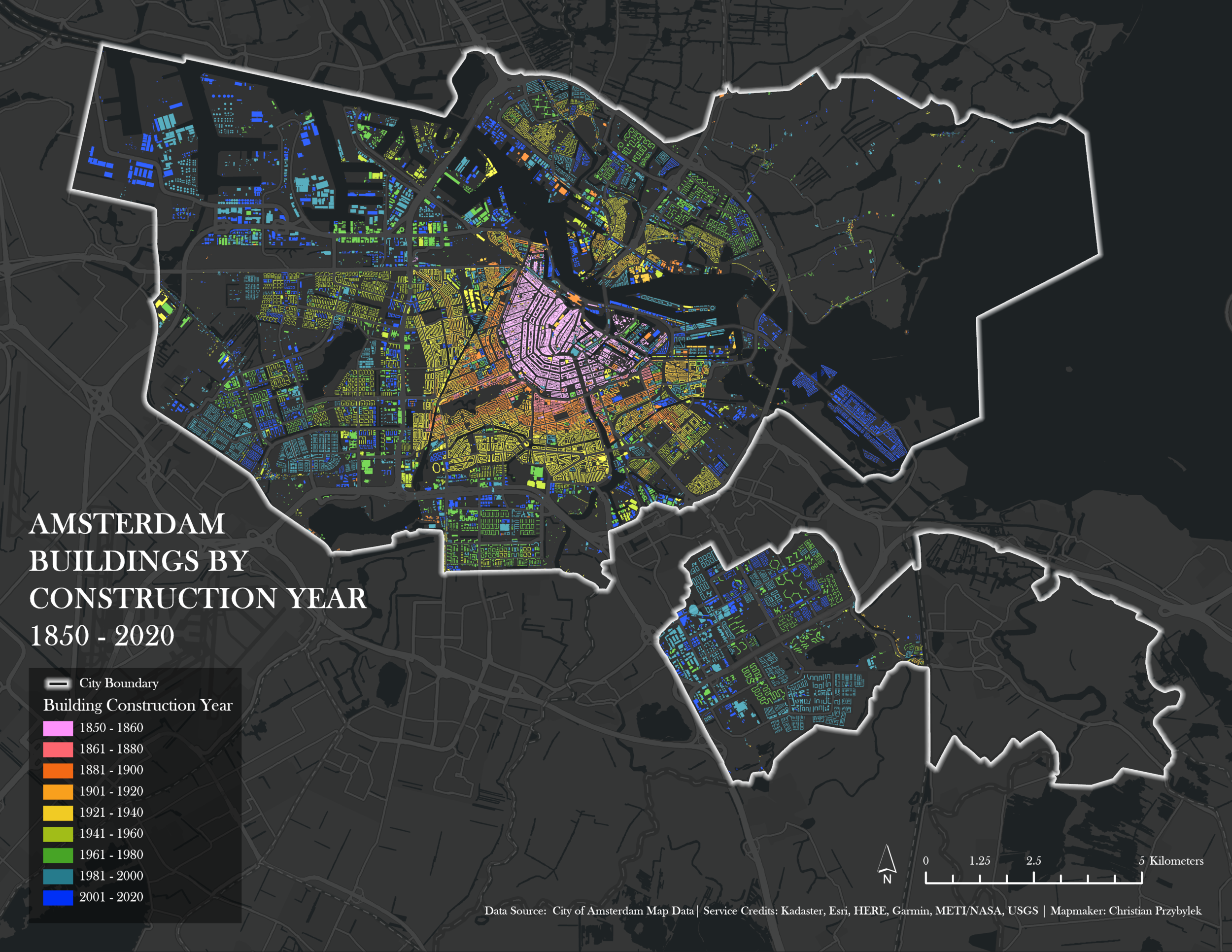
Amsterdam Buildings by Construction Date: 1850 - 2020
My challenge for today’s mapping project was to incorporate land. The broadness of today’s subject made it difficult to decide on a project and I bounced around several ideas before landing on today’s map: showing Amsterdam’s buildings by construction date. Amsterdam has historically been an important port city and is known for its beautiful canals and rich history. The city serves as the constitutional capital of the of the Netherlands (The Hauge serves as the country’s royal and administrative capital), a country defined by its relationship with the sea and a history of land reclamation projects (here is a great article showing how the country’s land footprint has growing since the 1300s). Mapping Amsterdam’s buildings by construction date seemed like a perfect subject for today’s land challenge.
Approach
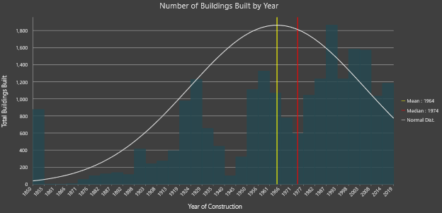
Before I had fully fleshed out my project, but knew I wanted to do something with Amsterdam, I perused an online library of the city’s spatial datasets, and found a buildings footprint layer that had construction dates for the corresponding structure embedded in the layer’s attribute data. This data point allowed me to show each building in the city by construction year, going back to 1850 and I decided to make it the focus of today’s map. Below is a graph showing the data of construction for each building in the dataset.
The distribution of the data is certainly interesting to look at. When mapping spatial phenomena, I typically start by reviewing the attribute table and running statistics on my subject, if available. I had trouble finding metadata or a data dictionary associated with this layer, but I suspect that buildings marked as being built in 1850 likely includes buildings built both during and before 1850. Another interesting aspect of the data is that one can see building booms following World War 1 (ending in 1918) and World War 2 (ending in 1945), following by a decline in building and another boom throughout the 1980s.
After reviewing the data and tinkering with they layer’s symbology, I decided it was visually overwhelming to map each building by its year of construction. I opted instead to group buildings by the decade they were constructed in. I created nine categories, mapping buildings built between 1850 and 1860, then proceeding in 20-year increments from 1860 - 2020. I also included the city’s boundary, as a white line. One curious thing about this boundary is that there are two detached parts of the city, a large area to the north, and a smaller detached borough to the south called Amsterdam-Zuidoost, which has interesting history in its own right. The 99% Invisible podcast did an interesting two-part series on a utopian urban renewal project that took place here, worth giving a listen to if you are interested in urbanism (part 1, part 2).
Overall, looking at how buildings are arranged by dates tells a story of urban growth and change. Visually, I was surprised by how neatly and well organized the buildings appeared to fit into concentric rings emanating from the city’s historic center, outward. Opensource data like this buildings dataset, freely provided by the City of Amsterdam’s government, are valuable resources for telling the important biographies of cities and how they dynamically change and reinvent themselves over time.

