Topographic Trail Map of Pennsylvania's Black Forest Trail

Map of the Black Forest Trail by Christian Przybylek
This map features the Black Forest Trail, a rugged and remote 42-mile looped hiking trail that traverses through north central Pennsylvania’s Tiadaghton State Forest and is nestled within the heart of the Pennsylvania Wilds.

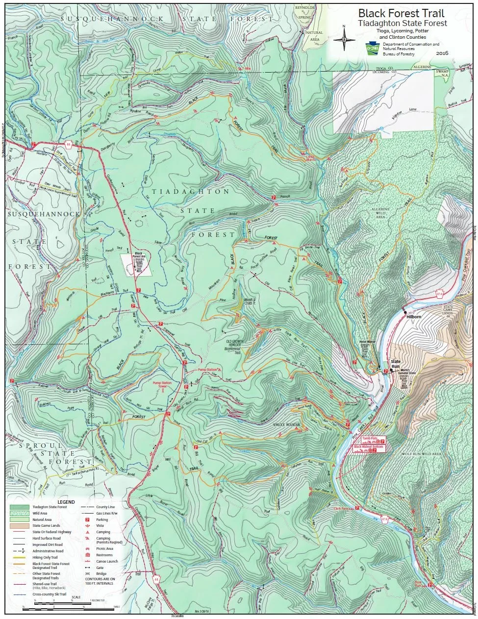
DCNR Map of Pennsylvania’s State Forest Trails
The Black Forest Trail (colloquially known as the BFT) is a special place for me and is one of the most memorable trail hiking experiences I’ve had. I discovered it back in the summer of 2015. My wife and I were in our final year of grad school, and it was grind. We were both attending school part time, taking evening classes and working full-time (50ish hour weeks) at non-profits and needed a break. We had started mapping out plans for post grad school life and landed on trying to complete a thru-hike of the Appalachian Trail (which we successfully thru-hiked a year later, in 2016!). While I was an avid backpacker and she loved camping, we recognized that a thru-hike of the AT was going to be challenging and we both would benefit from more experience and practice. At 42-miles, the BFT was something that could be done in 4 days and was the perfect trail to test ourselves and give us something to look forward to before summer ended and we went back to class. In August, we laced up our boots and left the hustle and bustle of Philadelphia for the quiet solitude of the Pennsylvania Wilds.
While I had grown up going out on multi-day backpacking trips, this was the longest hike I had taken at this point. My wife had been out once overnight as a teenager and together we had gone a handful of overnights on the AT, but none of our hikes were as long as the BFT. One thing we discovered was that we were not as prepared as we could have been, which was kind of the point of this test hike.
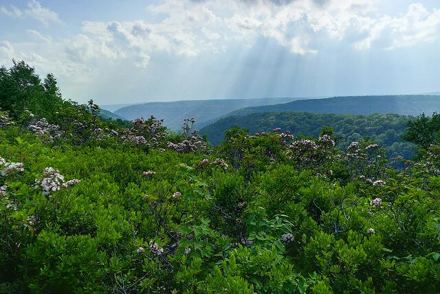
Photo by Rob Vaughn
We had packed an assortment of odds and ends, some things we needed, but a lot of things that superfluous to our packs and just added extra weight. Between us, we had two heavy winter mummy sleeping bags, a mess kit, a bulky water filter, a pocket rocket stove, a knife, some ponchos, two foam sleeping pads, a lightweight, but tight, “two-person” Kelty backpacking tent (which really was designed for one person), notebooks, and books (these were not a good idea in hindsight, for our AT thru hike we did bring a Kindle as an “luxury item”, which allowed us to read, but saved us some space and weight). We also wore jeans and cotton shirts, which we learned were not great for a long multi-day hike. Our clothes quickly got wet, heavy, and smelly. If I were planning this hike again, I would pack two pairs of running shorts (one for camp, one for hiking), a long-sleeved hiking shirt that I could adjust, a set of thermal underwear, some good wool socks and a pair of crocks (also for camp). I cannot recall exactly how heavy our packs were once they were fully loaded, but we had too much weight for a relatively short 42-mile trek. Still, we had an amazing hike, and it was an absolute blast!
The BFT is very scenic and covers a vibrant landscape. The trail traverses multiple mountains (I believe the trail has you climb seven mountains in total), which are covered in dense and ecologically diverse forests, interspersed with small meadows and beautiful edge forest habitats. Scattered along the trail are multiple vistas affording spectacular views across a seemingly endless horizon of mountain ridges. The forest also has an abundance of cold-water streams and small waterfalls, muddy wetlands and sandy springs and seeps. When we got on the trail it was the end of summer and our days were hot and muggy. However, once the sun began to set, the mountain air became cooler and the evenings were quite comfortable. During our four nights out, we endured multiple heavy downpours and thunderstorms, which was at times a little unnerving, but also kind of amazing. The weather also made for dramatic scenes at vistas, with clouds blanketing the valleys below and only the ridges of other mountains visible in the distance, making it seem like you were floating on an archipelago of sky islands.
For how beautiful this area is, I was surprised by how few people we met along the way. We felt like we had the trail to ourselves. During our hike, we encountered maybe two other hikers and a person doing work along a gas line corridor for a utility company. Perhaps it was the time of year, or the fact that were doing most of our hike during the middle of the week (we had started on a Sunday night and finished on a Friday morning), but I had expected to run into more hikers, not that we were complaining.
There was a lot of wildlife to enjoy from a distance. We saw plenty of deer, various species of song birds, and several species of snakes, including a few rattle snakes who kindly let us know of their presence. At night, warm in our sleeping bags, we heard the distant calls of coyotes howling and the persistent hoots of owls filling the chilled evening air and the rustle of tree branches gently swaying in the breeze. It was a gorgeous setting and an almost pristine environment. It also proved to be a good training ground for our future Appalachian Trail adventures.
The BFT is as rugged as it is remote. Some of the climbs are incredibly steep, requiring more technical footwork. It had sections similar to some of the more challenge sections of the Appalachian Trail. While the climbs up steep terrain was challenging, I sometimes found that going downhill was just as difficult, it not harder. Knowing what I know now of the BFT, if you are planning to hike it, I would recommend trekking poles. We did not have these along, but I think our knees would have thanked us if we had (we did pick these up ahead of our AT thru-hike and they really helped protect our knees, especially when going downhill). In terms of water, there were an abundance of streams, springs, and seeps as sources of drinking water. Of course, we always filtered our water (if you don’t, you really should), and I remember the water tasting fresh and minerally.
It was an exhausting couple of days, and we were both physically spent by the end of it, but it was also one of our most memorable hikes. The forest was alive with the accompanying sounds, sights, and smells of an ancient living forest, which has hosted humans for thousands of years, and it was beautiful. The night skies were also epic (when we had clear weathered nights). The north central Pennsylvania region has minimal light pollution and is known for its amazing stargazing. The BFT runs close to Cherry Springs State Park, known for having some of the darkest skies in the United States, making this the perfect area for stargazing. From the area, you can see a band of our Milky Way galaxy with the naked eye. If I were to do the hike again, I would plan to camp one night just below a vista and hike up in the evening to look at the stars (maybe bring a flask of whiskey and a banjo), assuming good weather conditions for stargazing. Those vistas would afford stunning views of the night sky on clear evenings. Especially if there was a meteor shower.
Approach for Making the Map Above
The BFT is one of my all-time favorite hikes and I wanted to see if I could make a map that effectively shows how varied the terrain of the trail is. My map incorporates multiple hillshades (both traditional and multidirectional) as well as a National Wetlands Inventory (NWI) layer to show hydrology, and a United States Geological Survey (USGS) basemap overlay. For the USGS basemap overlay, I experimented with various blend modes in ArcGIS Pro and settled on the luminosity mode. This brought the hillshade layers underneath the USGS topo map “up” and gave my 2D map a 3D feel. I then added the line layer for the BFT trail, displayed in orange to match the trail blazes. I also baked in some crinkled paper effects to make the final digital map look less “perfect”. With mapping as with most things in life, I find that beauty is found in the imperfections and trying to build imperfection into my maps helps avoid the uncanny valley vibes of a neatly rendered digital map that looks too clean. After a little fine tuning with layer symbologies, I landed on my final map of the BFT.
I also wanted to include an official map of the trail from the Pennsylvania Department of Conservation and Natural Resources, which you can see below:
If you are looking for a great, week-long hiking adventure in the Northeastern United States, I highly recommend checking out the BFT. you want to plan your hike and I highly recommend getting a BFT guide book. Its inexpensive, lightweight, and provides an excellent level of detail that will be indispensable for your hike. Happy trails!